 |
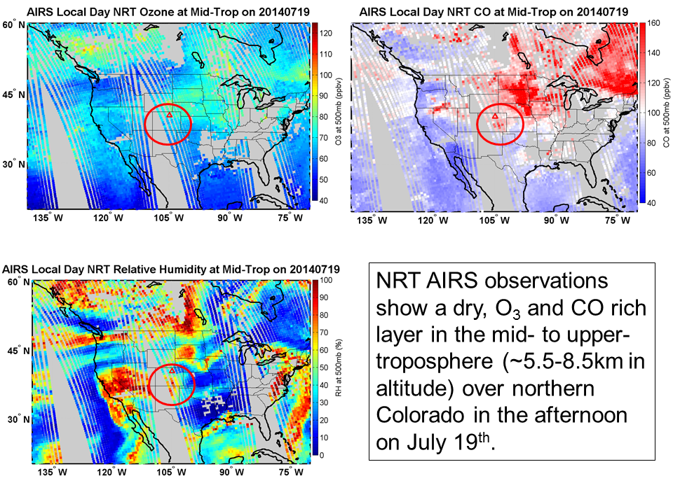
| AIRS Day NRT ozone (top left), CO (top right), and relative humidity (bottom left) at 500mb (~5.5-6.5km) via Debra Kollonige of ESSIC/UMD. |
Ozonesondes launched at Platteville show the progression of the smoke layer in the upper levels at 6-9km (on the 17th, 18th, and 19th) to its descent and dissipation at 5-7km (on the 20th and 21st) above the surface. The highest concentrations of ozone measured by the sonde are on the 17th (afternoon-left top below) as the smoke plume begins to enter the site area at 8km (~350mb) and the 20th (morning) at 7km (~400mb) before the air mass descends (bottom right below) and mixes into lower levels on the 21st. [See PSU Gator Ozonesonde Quicklooks for additional days.]
 |
| Ozonesonde profiles launched at DISCOVER-AQ Platteville-Colorado site July 16-21 courtesy of Ryan Stauffer of PSU. |
AIRS Day NRT trace gas measurements averaged over the Platteville area (retrievals within 50km) indicate the entrance of a smoke layer over Platteville by the 17th with dry, ozone and CO rich air in the upper levels. Peaking on the 19th, AIRS missed the higher concentration measured by the sonde on the 17th because of the course vertical resolution of the observations. Still, its time series of ozone, CO, and relative humidity between 5 and 9km shows the buildup of ozone and CO over Platteville 17-19 July, descent of the smoke/polluted air mass starting on the 20th, and its mixing/dissipation into the lower levels on the 21st. [See the UMBC Smog Blog at http://alg.umbc.edu/usaq/ for additional images of the descent of the smoke layer towards the surface via lidar measurements posted on July 19/20.]
 |
| AIRS Day NRT series of trace gases (ozone, relative humidity, CO and methane respectively top to bottom) observed July 16-22 at several levels including 500mb (black), 400mb (red), and 300mb (blue), which range in altitude from 5.5-9km. Figure courtesy of Debra Kollonige. |
Stay tuned for more satellite and DISCOVER-AQ measurements now that the mission has completed a few flights this week.
Spot on with this article, I really think this website needs more attention. I'll probably be back to read more, thanks for the info.
ReplyDeleteInnovation