Thursday, July 31, 2014

Gator Team Student Gives Poster Presentation at NASA Goddard Today

MD Gator Team summer intern and incoming University of Maryland College Park graduate student, Zachary Fasnacht, presented his current research at the Universities Space Research Association (USRA) Intern Program poster session today.

Zach Fasnacht (right) standing at his poster today with Dr. Debra Kollonige (left), one of his mentors this summer and Gator Team South member.
His poster, entitled "Effect of Stratospheric Intrusions on Tropospheric Ozone and Air Quality", demonstrated the combined use of aircraft, ozonesonde, and satellite-retrieved profiles for locating stratospheric intrusions during the DISCOVER-AQ Maryland (2011) deployment.  At the Edgewood-Maryland site, Zach found 4 days where stratospheric intrusions enhanced tropospheric ozone; however, surface air quality conditions were not effected on those days.

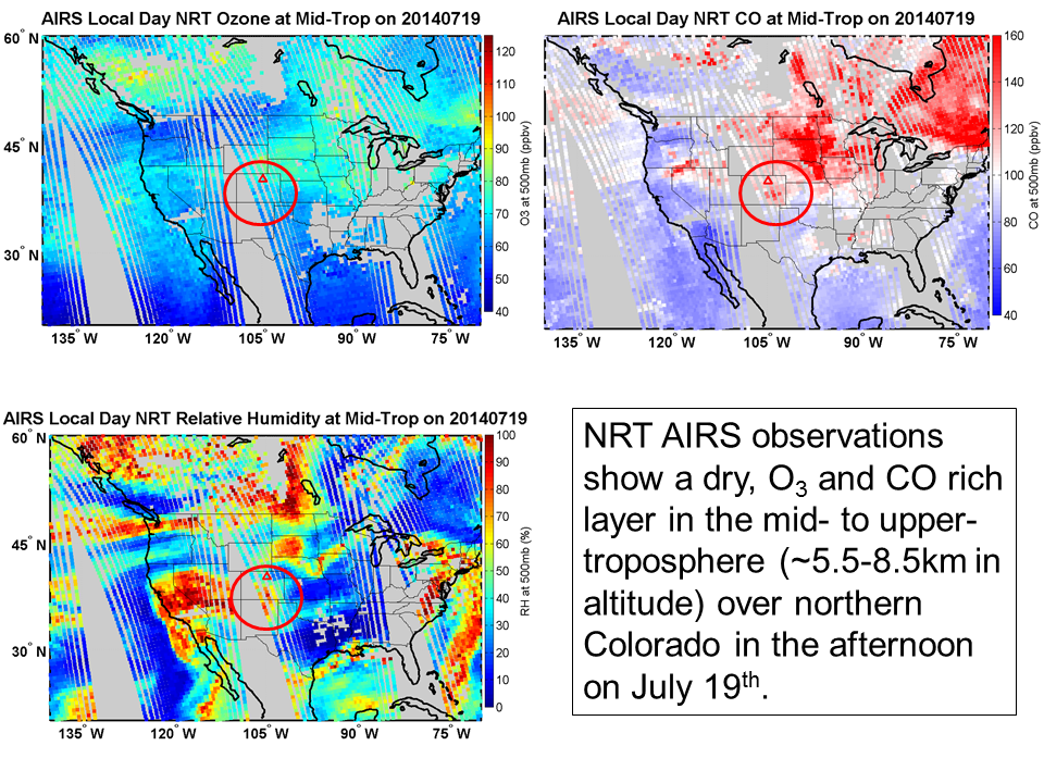
This project was mentored by Dr. Anne Thompson (GSFC) and Lesley Ott (GMAO).  Zach plans to continue this work looking toward other campaign deployments like the current DISCOVER-AQ Colorado 2014 field study.

Friday, July 25, 2014

Smoke Continued to be the Story Last Weekend at DISCOVER-AQ Platteville-Colorado Site

Canadian wildfires and fires in the Pacific Northwest effected much of the northern US last week, making the air in northern half smoky, hazy, and even having unhealthy AQI (Air Quality Index) levels of PM 2.5. AIRS NRT observations in the mid-troposphere (~5.5-6.5km) places a layer of smoke above the DISCOVER-AQ Platteville site on the afternoon of 19th of July (last Saturday). Elevated concentrations of ozone and CO (carbon monoxide) correlate with intensely dry air in this layer high above northern Colorado.  NOAA HMS Smoke and Fire Product on the 17th and 18th of July (shown in previous blog post) indicate a main smoke plume originating from fires in western Canada and northwestern US.  Additional HYSPLIT trajectories (not shown but verbal communication with Ryan Stauffer) suggests the source to be smoke coming from Canadian fires. 


AIRS Day NRT ozone (top left), CO (top right), and relative humidity (bottom left) at 500mb (~5.5-6.5km) via Debra Kollonige of ESSIC/UMD.

Ozonesondes launched at Platteville show the progression of the smoke layer in the upper levels at 6-9km (on the 17th, 18th, and 19th) to its descent and dissipation at 5-7km (on the 20th and 21st) above the surface.  The highest concentrations of ozone measured by the sonde are on the 17th (afternoon-left top below) as the smoke plume begins to enter the site area at 8km (~350mb) and the 20th (morning) at 7km (~400mb) before the air mass descends (bottom right below) and mixes into lower levels on the 21st. [See PSU Gator Ozonesonde Quicklooks for additional days.]
Ozonesonde profiles launched at DISCOVER-AQ Platteville-Colorado site July 16-21 courtesy of Ryan Stauffer of PSU.

AIRS Day NRT trace gas measurements averaged over the Platteville area (retrievals within 50km)  indicate the entrance of a smoke layer over Platteville by the 17th with dry, ozone and CO rich air in the upper levels.  Peaking on the 19th, AIRS missed the higher concentration measured by the sonde on the 17th because of the course vertical resolution of the observations.  Still, its time series of ozone, CO, and relative humidity between 5 and 9km shows the buildup of ozone and CO over Platteville 17-19 July, descent of the smoke/polluted air mass starting on the 20th, and its mixing/dissipation into the lower levels on the 21st.  [See the UMBC Smog Blog at http://alg.umbc.edu/usaq/ for additional images of the descent of the smoke layer towards the surface via lidar measurements posted on July 19/20.]
AIRS Day NRT series of trace gases (ozone, relative humidity, CO and methane respectively top to bottom) observed July 16-22 at several levels including 500mb (black), 400mb (red), and 300mb (blue), which range in altitude from 5.5-9km.  Figure courtesy of Debra Kollonige.

Stay tuned for more satellite and DISCOVER-AQ measurements now that the mission has completed a few flights this week.    


Friday, July 18, 2014

Canadian and Pacific NW Fires Observed by AIRS (7/14-7/18)

This week, VIIRS (Visible Infrared Radiometer Suite) and MODIS (Moderate Resolution Imaging Spectroradiometer) observed active fires in British Columbia (Canada) and the Pacific Northwest (Oregon and Washington mostly).  To determine the impact of these fires on air quality downwind, we examined AIRS (Atmospheric InfraRed Sounder) trace gases (CO, CH4, and O3) in Near Real Time (NRT).  Observations begin on July 14th, show the transport of elevated CO and O3 across the Front Range by the 16th of July, and an influence on the Eastern US today.

On the 14th (Figure 1):  NOAA's Hazard Mapping System (HMS) Fire and Smoke Analysis picks up active fires in British Columbia (BC) and Oregon.  Smoke from the BC and other northern Canadian fires spreads across northern US including NE Colorado.  AIRS observes correlated total column CO (TCCO) and total column CH4 (TCCH4) in the Pacific Northwest (red circle below) region and elevated mid-tropospheric CO (greater than 200 ppbv) over active fires in Oregon.    
Figure 1: Courtesy of Debra Kollonige.
On the 16th (Figure 2): Again active fires detected by HMS (bottom right) are associated with high mid-tropospheric CO concentrations measured by AIRS in NRT (bottom left). At this point, elevated trace gases (CO and O3) have reached Colorado (top); most likely influenced by both the ongoing Canadian and NW US fires.      
Figure 2: Courtesy of Debra Kollonige.
 Yesterday -7/17 and Today - 7/18 (Figure 3):  With fires still active, smoke has become widespread across the US (bottom: 7/17 left and 7/18 right).  Regions with correlated CO and O3 could be aged air from fire sources.  Even the Washington, DC / Baltimore areas are expected to have a noticeable impact from the Northwest fires (ie. pretty sunsets today from scattering off particles in the air.) 
Figure 3: Courtesy of Debra Kollonige and Meredith Nichols.


For quick plots of ground observations at Platteville-Colorado DISCOVER-AQ site:  visit the PSU Gator Team page at  http://ozone.met.psu.edu/dev/index.php.  For more images and tweets, follow @MDGatorTeam and @PSUGatorTeam on Twitter.


Wednesday, July 16, 2014

The Start of DISCOVER-AQ Colorado 2014

The NASA DISCOVER-AQ campaign deployment in Colorado is now underway with the setup of ground sites near Denver last week and the recent arrival of the planes.  Gator Team members from MD and PSU are hard at work setting up their site at Platteville, CO., located just fifteen (15) miles southwest of Greeley and thirty-seven (37) miles northeast of downtown Denver.  The PSU NATIVE trailer (Photo below by Ryan Stauffer) has a suite of instruments measuring trace gases at the surface and ozonesondes provide ozone and relative humidity profiles vertically in the atmosphere.


In preparation for the first flight of the campaign, researchers back in MD are viewing Near Real Time (NRT) observations from the NASA AIRS instrument (on the Aqua satellite) to provide context for pollution transport across the study region.  The example image below (courtesy of Debra Kollonige) shows carbon monoxide in the mid-troposphere for the US. as measured by AIRS, which is commonly used to trace pollution back to its source.  

Stay tuned for more updates throughout the campaign.  For more information about the goals of DISCOVER-AQ, visit http://discover-aq.larc.nasa.gov/. Follow all of our Gator Team South and PSU Gator Team activities on Twitter.